Palisades Park
- Known As
- Palisades Park
- Architect
- –
- Built
- 1892
- Designated
- 2007
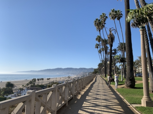
Palisades Park was gifted to Santa Monica by city founders John Percival Jones and Arcadia Bandini de Baker in 1892. The narrow bluff top park that extended from Colorado Avenue to the northern city limit at Montana Avenue was known as Linda Vista Park until 1915. The area between Montana Avenue and Santa Monica Canyon remained agricultural until Jones and Baker sold the tract to developers in 1904. It was annexed to the city in 1905. In 1908, the northern portion of the park became city property, resulting in today’s park boundaries which extend from Colorado Avenue all the way to the north city limit overlooking Santa Monica Canyon.
Palisades Park was a dusty ledge with a row eucalyptus trees along the Ocean Avenue edge in 1892. Shortly after it was donated to the city, H. Rowland Lee designed a landscape for the bluff with longitudinal walkways, formal entrances at the foot of each avenue, and a rustic fence and other furnishings made of eucalyptus branches. In 1898, in a scaled back version of the plan that only reached as far as Arizona Avenue was implemented.
By 1905 there were few plantings left, and the energetic new Park Commissioner, E.H. Sweetser, planted Monterey Cypress trees, shrubs, flower beds, and allées of palms along the full length of the park. These plantings were continued north of Montana by the owners of that portion of the bluff. Sweetser also began a multi-year project of installing the iconic rustic fencing along the edge of the bluff made from eucalyptus limbs salvaged during routine city-wide tree-trimming, completed in 1913. He was responsible for the 1909 construction of the redwood pergola built overlooking the California Incline, which was the inspiration for the Santa Monica Conservancy logo. And, he conceived and built the Idaho Gate in 1911, at the end of his term as Park Commissioner.
By 1913, there was a call to add grass and better lighting to the enhancements Sweetser had implemented in the park. Landscape architect, Louis J. Le Grande was hired to undertake the work. He presented a formal, geometric design that eliminated the meandering pathways and most of the mature trees in the park. Only one block, (between Colorado and Broadway Avenues) of his plan was ever implemented due to the vociferous objections of the members of the Santa Monica Bay Women’s Club. Since then, upgrades and replantings have occurred more or less within the framework established by Mr. Sweetser. In 1998-1999, the City undertook a 4.5 million bond funded renovation, which maintained the historic spaces within the landscape.
In recognition of its cultural and historic value, the park was designated a Santa Monica landmark in 2007. There is a marker at Santa Monica Boulevard and the park near the sidewalk that signifies the end of Route 66, the “Mother Road.” However, this marker was placed there by a film crew for a scene in “The Will Rogers Story.” Route 66 actually ends at the intersection of Lincoln and Olympic Boulevards, the 10 off ramp, where there is nary a marker to be seen. This does not prevent people from making the trip and driving on to the Pier to celebrate their completion of a drive on Route 66, believing the Pier is the end of the road.
In the park there are four stone markers honoring the Veterans of Foreign wars. There is a separate pillar dedicated to each branch of the Armed Forces. The monument was dedicated on November 11, 1999 and at the 11th hour of the 11th day of the 11th month, if the sun is shining, the pillars cast their shadow on the path below. The columns also align with the setting sun at the close of Veteran’s Day. This monument was designed by the architectural firm of Wallace, Roberts and Todd.